GUI Beschreibung
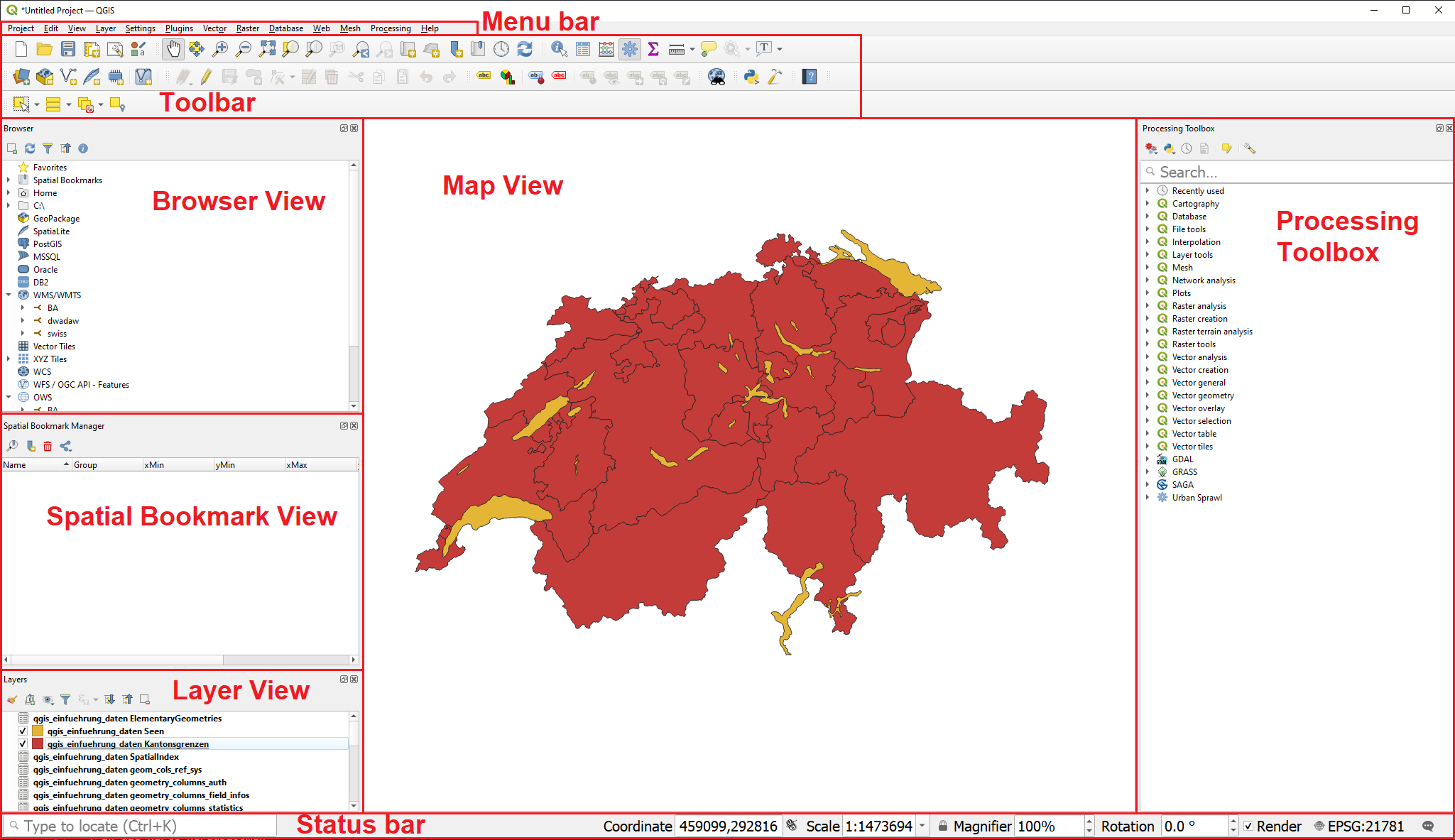
There are more Layers to the GUI of QGIS which arent visible. To open these click on . To open more Toolbars you are able to open them by clicking on
A different method is to right click on a grey bar in the toolbar area. Now you should be able to see both Panels and Toolbars.
Status bar

From left to right:
-
Coordinate: Show the coordinates your mouse is hovering over in the map window. The coordinates are in reference to the choosen Coordinate Reference System (CRS).
-
Scale: Shows the scale on which the map is visible on the map view. The scale can be changed by either zooming in, zooming out or by selecting one of the predefined options in the dropdown
-
Magnifier: By clicking on the
 lock you can enable the option to zoom in and out without altering the scale. The Default value is 100%.
 -
Rotation: Can be used to rotate the map clockwise.
-
Rendering: Can be used to disable the rendering of the map temporarily.
-
By clicking on the
 the dialog for the selection of the Coordinate Reference System opens.
 -
By clicking the
 the log messages show up.

Menu and Toolbar
Navigation in the map view
| Name | Menu option | Shortcut | Description |
|---|---|---|---|
Map pan |
Space, Page Up, Page Down or the Arrow Keys |
Move the map |
|
Pan map to selection |

|
Pans the map to the selected element |
|
Zoom in |
Ctrl+Alt++ or mouse wheel |
Zoom into the map |
|
Zoom out |
Ctrl+Alt+- or mouse wheel |
Zoom out of the map |
|
Zoom full |
Ctrl+Shift+F |
Zoom out to show the full map |
|
Zoom to selection |
Ctrl+J |
Zoom to the selected element |
|
Zoom to layer |
Zoom to the selected layer |
||
Zoom to native resolution |
Zoom to the native resolution (100%) |
||
Zoom last |
Zoom to the last zoom |
||
Zoom next |
Zoom to the next |
Project managment
| Name | Menu option | Shortcut | Description |
|---|---|---|---|
New Project |
Ctrl+N |
Create a new project |
|
Open Project |
Ctrl+O |
Open an existing project Opens the Dialog to create a new print layout |
|
Save |
Ctrl+S |
Save the project |
|
Save as… |
Ctrl+Shift+S |
Save the project as… |
|
Properties |
Ctrl+Shift+P |
Open the project properties |
|
New print layout |
Ctrl+P |
Opens the Dialog to create a new print layout |
|
Search |
Ctrl+K |
Opens the search bar |
Layer management
| Name | Menu option | Shortcut | Description |
|---|---|---|---|
Data source manager |
Ctrl+L |
Add a new layer |
|
New GeoPackage layer |
Ctrl+Shift+N |
Add a new GeoPackage Layer |
|
Add vector layer |
Ctrl+Shift+V |
Add a new vector layer |
|
Add raster layer |
Ctrl+Shift+R |
Add a new raster layer |
|
Remove selected layer |
Ctrl+D |
Remove the selected layer |
|
Toggle layers view |
Ctrl+1 |
Toggle the layers view |
|
Toggle browser view |
Ctrl+2 |
Toggle the browser view |
| Name | Menu option | Shortcut | Description |
|---|---|---|---|
Identify Features |
Ctrl+Shift+I |
Identify features on the map view by clicking on them |
|
Select feature |
Select a features by area or single click |
||
Select feature by value |
F3 |
Select features by value |
|
Open Attribute table |
F6 |
Open the Attribute table |
|
Open Attribute table with selected features only |
Shift+F6 |
Open the Attribute table with selected features only |
|
Open Attribute table with visible features only |
Ctrl+F6 |
Open the Attribute table with visible feautres only |
Advanced Tools
| Name | Menu option | Shortcut | Description |
|---|---|---|---|
Processing Toolbox |
Ctrl+Alt+T |
Opens the Processing Toolbox |
|
Python Console |
Ctrl+Alt+P |
Opens the Python Console |
For more shortcuts and information read the QGIS documentation
Additional questions? Contact the QGIS community!
![]() Frei verwendbar unter CC0 1.0
Frei verwendbar unter CC0 1.0